 FA+
FA+
1212
Views
Views
24
Favorites
Favorites
Category
All / Comics
Species Skunk
Size 907 x 1200
File Size 520 kB
Report this content
More from Chucky


Listed in Folders


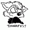
Now the aviation geekery starts. And what's aviation without a little weather? If you live in the Northeastern US or Southeastern Canada, panel #2 is a regular and very obnoxious occurraence.
The white vixen in panel #1 belongs to gadgett.
The white vixen in panel #1 belongs to
 gadgett.
Category All / Comics
Species Skunk
Size 907 x 1200px
File Size 520 kB
Listed in Folders


Actually, for domestic weather, they are prolly the same.
Here, were getting a kind of "decoded" METAR. METAR is a weather report for pilots.
I will give an example of a full METAR then decode it
KSEA 290653Z 23012G24KT 10SM BKN019 OVC024 10/06 A2980 RMK AO2 PK WND 22030/0604 SLP099 T01000061 $
So, we get this from that
At Seattle Tacoma International (KSEA)
Wind is coming from 230 degrees at 12 knots gusting to 24
Visibility is 10 miles
Broken cloud cover at 1900 feet
Overcast clouds at 2400 feet
its 50 degrees F, dewpoint is at 42 degrees F
Relative Humidity 76 percent
Barometer is 29.80 in. Mercury
Simple, right?
Actually, they are giving more of a TAF report, my bad. Similar in design tho with a bunch of code.
TAF is the international standard code format for terminal forecasts issued for airports. The acronym translates to Terminal Aerodrome Forecast , and is analogous to the terminal forecast (FT) coding format currently used in the US.
TAF is the international standard code format for terminal forecasts issued for airports. The acronym translates to Terminal Aerodrome Forecast , and is analogous to the terminal forecast (FT) coding format currently used in the US.
Various single engine Cessnas. I only rated VFR Single engine land. Was good enough for me to at least get that far. Growing up around aviation for the first 10 years of my life when dad worked for the airlines gave me the bug, but not to want to be a Transport rated pilot.
Sorry to hear you're not in it anymore. But man that shit is expensive now. I learned in a Cessna 152 for $38 an hour in the mid 1990s. I think the 152 is around $75 an hour now if you're lucky enough to find one. Otherwise you're paying over $100 an hour for a 172 now days.
This was pretty much why. Cost.
I was working during the "Dot Com boom" era with a profitable contract so it was easy to afford then. In fact, I used my company AmEx card to fund it while I was hanging out with some friends from the Denver area. Wrote the expense off as a "business meeting" and no one blinked.
After that things were tight for a few years but got to a point I could again, but my new job kept me so busy i just never got back into it.
Then this past January I got let go, and well, seems every ten years I have to do a life and job reboot.
I will get back up there though eventually. Nothing comes that close to heaven while were still alive IMHO 8-)

It's close. I think a nor-easter tends to ride up the Atlantic coast more, pulling incredible amounts of moisture with it. Then, as it moves off the coast to the northeast, the northeasterly winds behind pull lots of cold air from the north, combined with moisture from the Atlantic Ocean to dump very large amounts of snow, usually on New England..
If anyone wants to add to that explaination, feel free.
If anyone wants to add to that explaination, feel free.
oh poopy....lol just kiding man when ever you have time im not the demanding type(despite im the chatist guy here lol) if it takes awhile its awhile no rush and just to answer a nag i have are there "scalies" in chuckys world or just mamals? if so thats kinda a bumber cuz im a "scalie" without the scales lol but if its only mamalia thats kind specists dont ya think? i under stand no flying or winged furs (even though i am one lol) just noticed an def lack of herpatile types in your work?


Everywhere has its challenges. On the front range, you have density altitude, high mountains, wicked turbulence potential, and mountain weather. But I've never flown ANYWHERE that had more congested airspace, more IMC, more ice, more weather, or more potential for controled flight into terrain than the Northeastern US, and it all can happen below 3000 feet.
I think it was in NY, I will have to look it up my memory of the event was something I read about a long while back and I might have the details wrong but student pilot (think he was famous sports star), and his instructor got in fog over NY, got into some tall buildings in the city and ended up where there was not enough room to turn around in. So it does not always have to be terrain, but its the same idea. CFITs should not happen, but we are all human.
The first thought I learned from instructors was *Aviate, then Navigate, then Communicate*
The first thought I learned from instructors was *Aviate, then Navigate, then Communicate*


Comments